LIVETRAKING
RELIEFMAP

Race timetable :
May 1, 2026, 22:00: Registration closes.
May 22, 2026 (latest):
Route announcement.
Friday, May 22:
-
From 6:30 pm: equipment check & participant profile photo for the live feed.
-
7:30 pm: briefing.
-
8:15 pm: dinner with registration (Telegram group poll).
Saturday, May 23, 2026:
-
7:30 am: final equipment checks & participant profile photo for the live feed.
-
8:00 am: distribution of trackers.
-
8:30 am: group photo.
-
9:00 am: START from the Moutier ice rink.
-
8:00 pm: end of the first day.
Sunday, May 24, 2026:
-
8:00 am: start of the second day.
-
8:00 pm: end of the second day.
Monday, May 25, 2026 (Pentecost):
-
8:00 am: start of the second day.
-
4:00 pm: STOP of the stage.
-
4:30 pm: prize-giving ceremony.
-
Meal upon your arrival at the Tourism Office.
WAY POINTS
The way points can be validated in various ways:
-
Validated in flight or on foot, radius over 200m.
-
Validated foot on ground, radius 150m.
-
Signboard and / or selfie, radius 50m.
MOUTIER
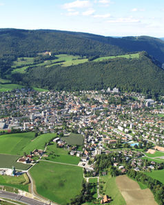
JURAairTOUR is based in Moutier in the heart of the Jura massif, a small town of just over 7,000 inhabitants in the north of Switzerland. Moutier is known for its swimming pool, its climbing spots but also for its biannual GRAITRICKS event which takes place every two year.
JURA MOUNTAINS
The Jura mountains are located along the border between France and Switzerland, northwest of the Alps and south of the Vosges region. This banana shape range stretches for over 360 kilometers between Dielsdorf and Voreppe, following the curvature of the Alpine arc. The highest peak is Cret de la Neige at 1'720 m.
Northern Switzerland is an ideal playground to begin whith the hike and fly discipline. The low mountains and vast pastures guarantee take-offs and landings. In contrast to the the Alpine valleys, the JURA range of mountains is not subject to valley winds but is exposed to meteorological winds.


